
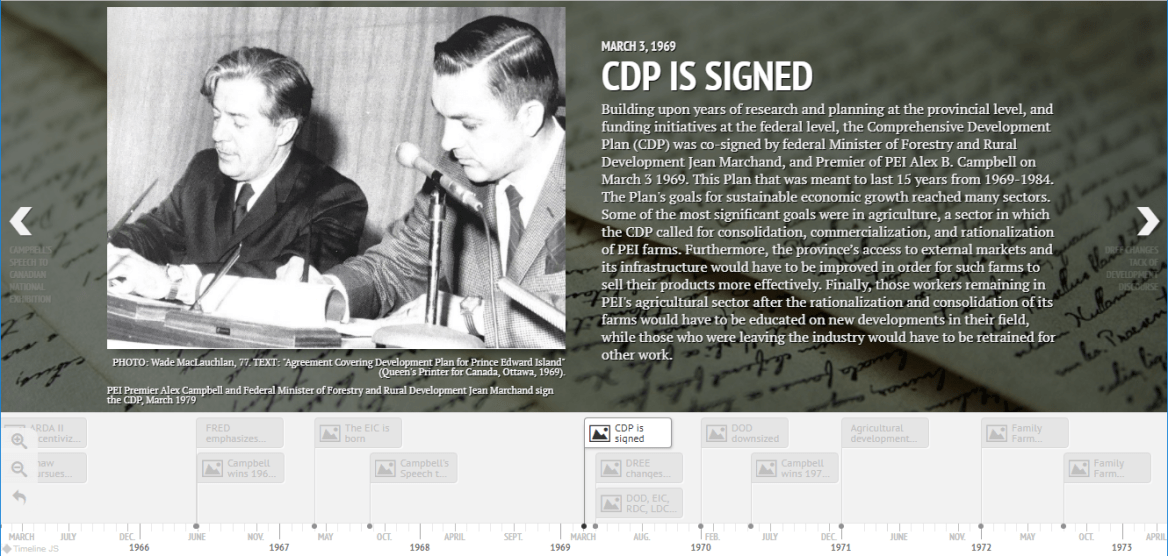
The roots of Canada’s food system run deep. They permeate every part of our geography and history, and they are shaped in turn by regional patterns and historical processes. But did the roots of our modern food system grow wild, at the hand of millions of market responsive farmers, or were they planted and planned by the state? Clearly the answer includes bits of both, and it changed over time. Modern agriculture is often called some variation of a revolution or a great transformation, but in reality it emerged in fits and starts. The twentieth century contained many cases of central planning in agriculture. It also included many modernization plans that failed, and others that were significantly reshaped by local communities. In Prince Edward Island a federal-provincial modernization effort known as the PEI Comprehensive Development Plan (CDP) illustrates the recency of – and frequent resistance to – high intensity agriculture in the Maritimes. What follows is just one story, among the many tangled roots that we are tracing in the lab for GeoREACH (Geospatial Research in Atlantic Canadian History) at the University of Prince Edward Island. Taken together, these narratives help explain the central role that food and agriculture, and rural environments, played in the modernization of Canada and the world. They help us understand how policies shape land use and cover change over time, and how farmers sometimes make other plans entirely. The Comprehensive Development Plan was more a rhizome than a root in this story. The larger plan has been called a watershed and even “the break” in PEI social and economic history. We created a timeline to illustrate its political and policy history (see below), but in this piece we focus on its role in agriculture. Signed in 1969, the CDP was originally intended as a 15-year long regional development initiative. It was meant to modernize practically every aspect of life on Prince Edward Island, ranging from agricultural development to educational reform. Managed in coordination between the Canadian federal and the PEI provincial governments, it was the most comprehensive, ambitious, and expensive regional development plan in Canada to that date. Its plan for agriculture, and the tepid response among Island farmers, say a great deal about the divergent visions of food and development in 1960s Canada. When experts examined the region’s agriculture in the mid twentieth century, they often concluded that it was backward and inefficient. They recommended a judicious application of training, environmental resource data, and financial incentives so that farms could consolidate and become more specialized in commodity production. They also produced extensive maps and surveys for the Island that we are now able to incorporate into historical GIS research in the GeoREACH lab. Some of the surveys were illustrated by the National Film Board’s documentary on the CDP (see the video below), and many of the maps became part of the Canada Land Inventory (see the feature image). After decades of research into the region’s natural and economic assets, the experts tended to agree that the region could support a smaller number of profitable “commercial farms”; under the terms of the CDP they could even triple the net value output of these farms. However, as one report concluded, smaller farmers were reluctant to sell, and “it seems that the improvements in agriculture, needed to achieve this output, involve changes in rural society.”[1] The Plan emerged within the post-war context of regional development and central planning. Following its 1961 predecessor, the 1965 Agricultural and Rural Development Act (ARDA II) was designed to fight regional disparity. It did so by stimulating growth in so-called peripheral regions and helping them to “catch up” with wealthier regions. Prince Edward Island benefitted from several such postwar initiatives, but the federal program that allowed the CDP to be truly “comprehensive” was the 1966 Fund for Rural Economic Development (FRED). ARDA tended to focus on distinct land use projects such as dams and drainage, but FRED offered much larger funding packages to regions if they implemented development plans that were fully comprehensive, meaning that they addressed both economic and social challenges. Under FRED’s criteria, the whole of Prince Edward Island was designated as a “Special Rural Development Area.” PEI was the only province to receive such a designation in its entirety, but projects in provinces like Newfoundland and Quebec had important variations.[2] PEI politicians like the Progressive Conservative Premier Walter Shaw were enamoured by ARDA and other research-intensive development projects. Shaw formerly served for two decades as the PEI Deputy Minister of Agriculture. In 1965, his government commissioned a series of reports on the state of the economy and society from Acres Research and Planning Limited. These reports would cover the potential for developments in agriculture, production and marketing, municipalities and urban centres, forestry and woodlots, and more. In May 1966, Liberal candidate Alex B. Campbell won the provincial election with a slim majority over Shaw, and he proceeded to assemble an agency that could take advantage of the FRED program and pursue federal funds for a comprehensive plan that would span the Island.
