As a Man Sows: Spring Planting, Prices, and the Birth of Monoculture on PEI

It is now common to read statementslike “Modern industrial agriculture is a disastrous failure, as it defies practically every natural law related to food cultivation, ecological and environmental protection and stewardship, and human nutrition.” But if this is true when did it begin, and why did new settlers decide to farm in this way? On this the last day of Spring, Real Time Farming looks back on the planting and other spring activities on nineteenth century farms like John MacEachern’s.

Spring planting: Prince Edward Island Potatoes
Photo: Josh MacFadyen

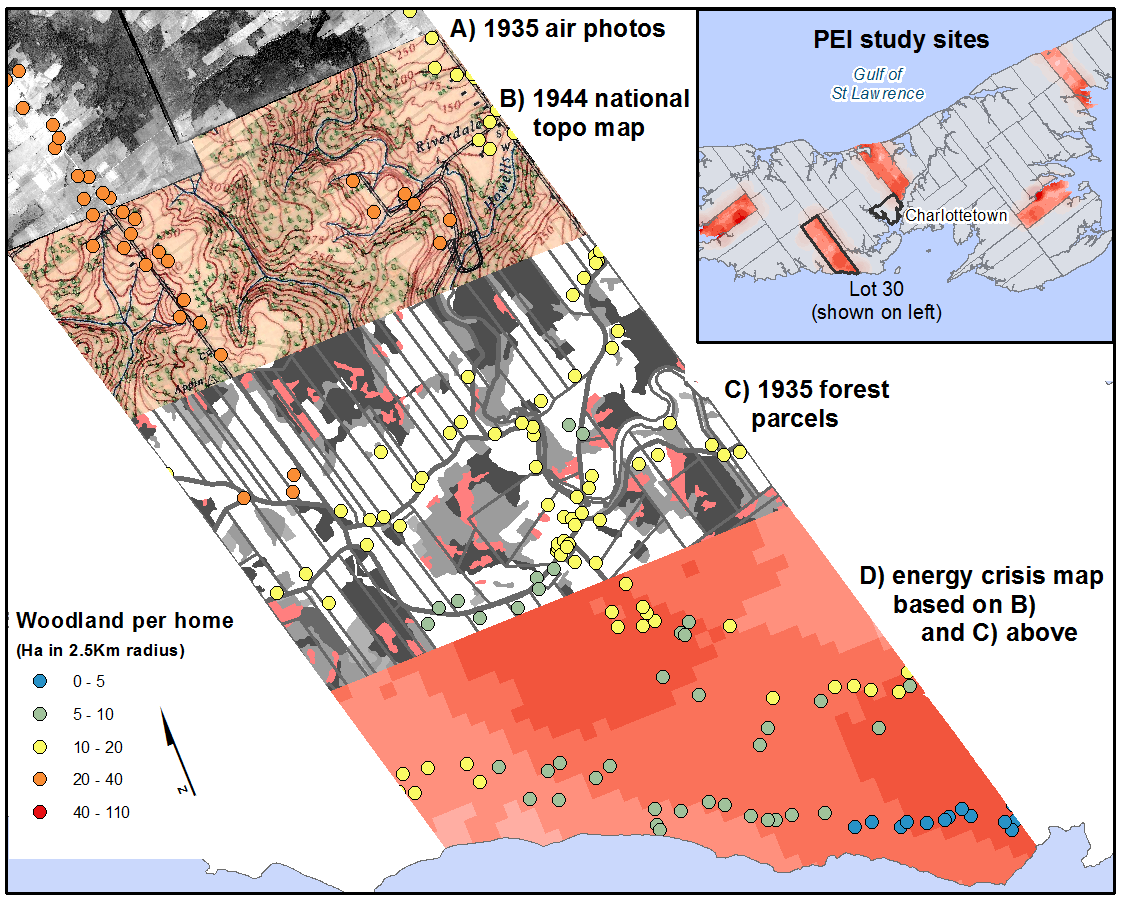
The earliest farmers in Atlantic Canada raised crops and livestock by maximizing the natural productivity of salt marshes. Wetland drainage was still a human disturbance, but at least it required limited deforestation. As population and farm settlement expanded the salt marshes represented only a fraction of the necessary caloric production, and farming became much more intrusive.

Since then, the farmer’s work has been to kill off, uproot, and fence out all of the biodiversity from an acre of land, and to plant and cultivate a single crop in its place. The old family farm might seem to us a distant sentinel of a lost way of life, but they were hardly timeless and uniform. Like all institutions that manufactured goods farms were dynamic systems and businesses, too. Decisions were based on complex variables such as climate, prices and markets, the availability of labour, community growth and decline, and changes in local diets and consumer demand. As petro-chemical fertilizers and pesticides became available they began to replace locally available soil treatments such as manure and mussel mud.

A progressively complex and experimental style of farming is visible in the diary of John MacEachern, who settled a farm in Rice Point in the mid 19th century. In the cold wet spring of 1866 MacEachern planted wheat, oats, clover, potatoes and a small amount of flax seed. Other work included building fences at home and markets in Charlottetown. The mare gave birth to a foal and the sheep were sheared for their wool.

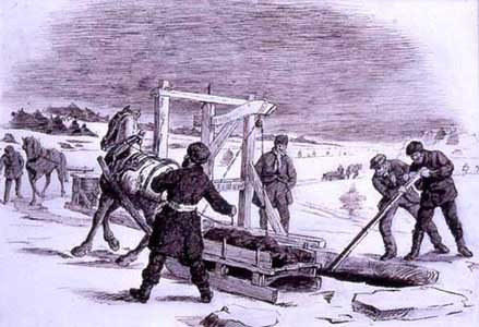
In 1879, the spring activities in Rice Point were much more diverse. The sheep produced another coat for the shearer in June, and John’s neighbours, Doug and Jane MacDonald, processed all or part of the wool. Pork was butchered for urban markets, fish were harvested from multiple locations, and MacEachern’s sons were busy with heavy work such as picking rock, hauling mussel mud and pulverising, planting, and rolling the new crops.

Spring Planting: PEI
Photo: Josh MacFadyen

The crop selection was extremely diverse and reflected an ability to experiment with different plant varieties and methods of cultivation. Simple pulverising was replaced with “cross plowing,” harrowing, and pulverising crops before and after planting. Crop diversity increased, and even the grass seed used for hay included ТО lb each of Alsac, Dutch, and Red & White i.c., as well as “some Eng Red & White and ТН bushel Timothy.” Hay was a critically important crop for farms interested in increasing their ability to carry herds of cattle and sheep safely through the winter.

Other work in 1879 included fencing, cleaning seed, and cutting and burning “bushes” along the margins of the farm. These bushes were likely self-seeding conifers from the hedgerows and suckers growing on the stumps of cleared land.

A more interesting picture of the MacEachern’s farm landscape emerges in 1879, as John begins to think of his fields according to their locations and uses. The “bushes” and “new land” were located at the back of the lot and “outside of back fence,” and presumably the “new field” was either the same space or a field nearby. The “middle field” was on the water side of the house and had recently been lea, or pasture, and it was being pulverised and seeded to grass again in 1879.

Grass and oats fed the animals on this busy farm, and animals were essential for producing the potatoes, firewood, pork, and wool necessary to keep the MacEachern’s engaged in urban markets. Trips to “Town” were an important part of life in both the 1860s and 1870s, and the farmers made the journey both as producers and consumers. The city was the nexus for information and trade, and the most visible trend in the farm’s development was the increasing complexity of its market relationships. As MacEachern’s children came of age and became more available for farm labour, the extent of clearing, the complexity of cultivation, and the range of marketable products increased in turn.

Rice Point, PEI

May 1866

9, I went to Town for clover seed. Heavy rain.

14, I sowed wheat, five bushels

15 sowed 4 bushels of oats

16 sowed clover seed, 10 lb in 4 acres. Sowed 3.5 bushels oats on the upper turn hill and 2 lb red & white clover seed.

17. Rain showers and cold. This day 36 years ago we landed in Ch-Town the woods were green, no leaves yet. Dry now a week.

18 Sowing oats in lay land in swamp field at night mare foaled, 4 days less than a year.

19, Raining. Good fishing last week at Canoe Cove, slack at Nine Mile Creek.

24, Fine. Showry & finished sowing oats in swamp field, 15.5 bushels in 4.5 acres

25, Fine, Sheared the sheep & planted potatoes

26, Doug to mill with wheat

29 In the morning rain cleared up, I walked to ferry , to Town to Mr C W Rights

30, Overcast and raining, we planted potatoes

31 Fair, we planting potatoes, raw and cold this month.

June 1866

1, Fine, Doug and I to Town

3, Sab. Meeting in Canoe Cove

4, Sunny, the woods scarcely in leaf till this month

5, Rainy, we trucking poles to shore fence, sowed flax seed yesterday 1.5 pecks in the 1/8 of an acre

6, gloomy but mild, putting up shore fence

7, Telegraph dispatch from Canada on Sat eve last that Fenians from the Yankee’s side had encamped there…

Rice Point, PEI

May 1879

1 Thunder and a shower

2, Raw, I to Town by (Ftr, Ltr, Wr?) put note in bank, sent a letter to Cousin McFlet. & remins.

3, Warm, finished pulverising two ridges new land left in the fall

5 morning red, rain after breakfast boys went to haul mussel mud

6, foggy, Doug to Town R Ts, Potatoes 45 cents, I sifting wheat

7, misty, D & L hauling mud, Neil pulverising lea

8, I sowing wheat, 10.5 bushels below R.W.

9, Sowing Canadian clover, Alsac, Tim (Boston) on West side

10, I to Town for Eng. Clover & Alsac at Beer Brothers & Tim. & White to at Sellar’s. In the evening sowed Do in wheat, East side of field

13, I & Ln to Town, I across West River to J.W. Crosby’s

14, Hot, Neil finished planting Goodriches & Blue in lea land, middle field, below house, 4.5 acres.

15, Windy, Doug at field NW of house, oats 42 bu in 9.5-10 acres. Part pulverised before, and part after sowing.

16, I to Town paid Conr Bk by Cash from Cn day.

17, S. To W. Cloudy, N hauling potatoes & Lauchlin rolling oat field.

18, Sab. Minister Goodwill in C. C. Church.

19, Misty. 49 yeares today since we landed in Ch-Town out of the Brig “€œCorsair of Greenock,”€ passage about 45 days from port to port, the trees here were in full leaf, not so very early since.

20, Rained some last night. N.E. Misty, Neil plowing W Brookfield. E Side Doug sowed on Sat 13 Bushels. Evening, Minister in T. House, Text Galations 6: 7-10, an excellent sermon.

21 hauling stones off, near new land. Evening a heavy shower. Minister to Rocky Pt. Woods turning green now.

22 N. Cold. Sowed near back field, about 11 bushels. Evening cold and windy. Froze.

23 Ice on water at well. Doug & Christy to Town, took carcass of pork. I sowed near new field. Oats. Neil and Ln carting off stones. P. Aunt Julia came through woods.

24, NE. Blowy and cold, harrowing couch in lower W. Field for potatoes. Evening, Ln to Lobster Factory.

26, I sowing grass seeds in near Glenfield (Alsac ТО lb, Red & White i.c., Dutch ТО, some Eng red & White and ТН bushel Tim.). Rained PM fair, Neil at couch pulverizing, Doug harrowing grass seed.

27 AM W. Windy and cold and for some days past, very backward for vegetation, stormy for fishing, a thin skim of ice early

28 W. Windy, N&D finished cross plowing for potatoes, lower W field, dry. I burning trimmed bushes outside of back fence.

29 Hot & dry, PM rolling oats in new land & c.

30 AM calm, read Ezek Ch 16, Doug & Neil carting manure to lower W. Field, PM windy, much smoke from W. Dry.

31, W. Breezy & dry for some time, John McRae here helping to fill manure, day smoky & dry, hauled over 50 carts to K.

June 1879

1, Sab. Dry. Douglas the Bible C. Agent in Mg.

2, rained heavy before and after day break, much needed for crop & grass, cleared, D&N hauling M. Still from yard.

3, NE overcast, sent a letter to brother Neil in Buctouche h & one to Chas. Widow in Fredericton NB, we spreading manure for potatoes

4, AM some rain we began planting potatoes in lower W. Fields, some Pern on E. Then ten bushels Pr. Acre afterwards.  Perusi & a drill or two Comptons, and a few Brooks, and some Scotch Victorias in two places, and 8 bushels rose potatoes.

5, at potatoes

6, at potatoes

7, a gale. We finished planting as above

8, Sab. A hail shower at day break, day cool

10, hot, Doug & Jane McDonald shearing our sheep, 36 sheep 14 lambs, 3 not altered.

11, J. McDonald washing wool

12, SE, Neil hauling poles across the brook for pasture. I levelling road, Doug at Donald’s at mud frolick

13, … heard that Lowther was writted for Oct. Court expences

Aerial Photographs, Forest History, and P.E.I.’s First Energy Crisis

(First published on The Otter, May 12, 2012)

Recent studies of aerial photographs suggest that Prince Edward Island’s first energy crisis was not the 1973 oil embargo but a firewood shortage that predated OPEC by a century. Two posts on The Otter discuss some of the ways air photos can be used to understand landscape change in the PEI National Park, and a new exhibit stresses the importance of seeing these images as snapshots of time as well as place. Air photos can also be used in a Geographic Information System (GIS) to study land cover and land use change, and the resulting data offer a new tool for understanding the difficult balance between clearing forests for agriculture and leaving enough for fencing, forage, and fuel.

Tourists who approach Prince Edward Island on the ferry in 2012 disembark at “Wood Islands” and take in a coastal landscape of relatively unbroken forest, but the ferry’s first passage in the late 1930s would have revealed a very different and almost completely denuded coastline. (Early tourist invitations to “come play on our island” might have included a suggestion to “bring your own firewood.”) The 20th century forest regeneration at Wood Islands echoes a well known story of outmigration and agricultural downsizing in the Atlantic region, evident in sources like the Census of Agriculture. Historians assume that farm abandonment occurred primarily on marginal lands, as families adapted to poor soils and a poorer economy, but air photos offer a detailed portrait and a spatially explicit model of different stresses such as declining access to woodlots and other wildland resources.

At the beginning of the 20th century Prince Edward Island’s forests had reached a nadir from extensive agricultural and commercial exploitation of the forest. But only a generation or two earlier, there was an abundance of forest. In 1861, the average Island farmer lived on properties which were only about 38 percent “arable,” or cleared to the extent they could be cropped. Taking into consideration the other thirty percent of the colony not in farms, we see that only about a quarter of the Island had actually been deforested. Forest historians argue that by the end of the century over 70 percent of the Province was cleared for agriculture and the forest that remained had been harvested several times for the shipbuilding industry and domestic use.

In a recent Otter post I described how Prince Edward Island farmers responded to a critical food shortage, when the Province’s ruminant population outpaced its marsh and upland hay production. Farmers took to the ice and spent a large part of the winter dredging “mussel mud” to enrich their fields and expand the production of hay and cereals. However, this practice was prevalent in areas where farmers had already cleared most of their land, both because growth required either new land or more productive land and because farms in these areas were running out of firewood. With little forest left, many of these farmers turned their winter activities to hauling mussel mud and began to buy coal or commercial firewood for domestic energy.

Using air photos it is possible to identify places where this likely occurred. Figure 1 shows a composite image of four map overlays (labelled A-D on the right) and the location of every home in Lot 30 (labelled on the left), a rural township to the west of Charlottetown. These layers allow me to identify the precise location of homes, the location of the forest, and the places where the density of homes and scarcity of forest would have caused a biomass energy crisis. These data are all derived from PEI’s aerial photographs which were first flown for many Canadian jurisdictions in the 1920s and 1930s. The original air photos were subsequently used to create maps for the National Topographic Series, and in 1990 the Province of PEI also used them to create historical forest and land use inventories. In the final layer, I used a GIS to measure the amount of forest located within a 2.5 Km radius of each home and made an “energy crisis map” based on the density of points in selected PEI study sites.

pei-macfadyenmap1935
Figure 1: Forest history data derived from air photos, Bonshaw, Lot 30, P.E.I. 1935. Photos and inventory courtesy of PEI Dept of Forestry.

This map shows areas where rural and small town resettlement was putting pressure on natural ecosystems. For example, Lot 30 had approximately 14 hectares of forest for every home, but the homes marked with blue dots had direct access to less than 5. Clearly these farmers lived in an interconnected world and had access to fuel from local outfits and importers, but what is important here is that their immediate fuel supplies would not have lasted more than a few years at even a conservative rate of consumption.

Additional research and a presentation at the Canadian Historical Association / Canadian Association of Geographers at Congress 2012, in Waterloo, will show what kinds of woodlots remained in the most densely inhabited areas. We might expect that harvesting was most intense in those areas and regenerating plots were not. The forest inventories recorded not only the outline but the cover type of each forest parcel, and GIS lets us query the inventories for these sorts of questions.

The 1935 PEI inventory may be the earliest in Canada, and due to the Province’s small size and complete air photo coverage it is certainly the most comprehensive. Behind the inventories, however, are ordinary air photos, and researchers interested in recreating topographic features can find great coverage of local areas at university libraries such as Brock, Dalhousie, Toronto, Waterloo, and Western. For larger areas consult the National Air Photo Library’s enormous collection and online search engine in Ottawa. All air photos contain distortions, and if your research relies on accurate locations, distances, and measurements it is important to correctly “georectify” and digitize these features with the proper projection in a GIS. Many <href=”#/Fundamentals_for_georeferencing_a_raster_dataset/009t000000mn000000/”>online tutorials are available to help with these processes. If you only require the general description and location of topographic features then you might want to use the closest National Topographic Series (NTS) map for your period of interest.

Aerial photographs, NTS maps, and historical forest and land use inventories offer a new way to study the relationship between farms and forests. If the NTS maps were a sort of census of the Canadian environment in certain years, then aerial photos were the original manuscripts behind the printed census. Just as social and economic historians often need to consult the nominal censuses for a new level of detail, historians of the environment can find information in the original air photos (e.g. forest types, land use, coastal erosion, building location/orientation, sub-urban spaces, pollution and brownfields, etc.) that may not have interested the cartographers.

Further reading:

  • D. G. Sobey and W. M. Glen, “A Mapping of the Present and Past Forest-types of Prince Edward Island,” Canadian Field-Naturalist 118 (4) (2004): 504-520.
  • There are several chapters of interest to NiCHE readers in Historical Geographic Information Systems in Canada a forthcoming book edited by Jennifer Bonnell and Marcel Fortin. The chapter by Joanna Dean and Jon Pasher uses air photos and other sources to measure urban forests, and Joshua MacFadyen and William Glen have presented a longer discussion of the PEI forest inventories in “Top-down history: Delimiting forests, farms, and the Agricultural Census on Prince Edward Island using Aerial Photography, c.1900-2000.”
  • Don Valley Historical Mapping Project
  • GeoWATCH: Geospatial Workshops in Atlantic Canadian History
  • NiCHE Resources for learning and developing Historical Geographic Information System (HGIS) projects.
  • National Air Photo Library

Real Time Climate Change: Farm Diaries and Phenology in Prince Edward Island

(A guest article posted by Joshua MacFadyen on www.activehistory.ca)

It is 24 April, and although some Canadians have been mowing grass for weeks the spring plants on Prince Edward Island are only beginning to overcome the cold nights and occasional flurries that visit this island in April. Still, this is an early spring by historical accounts. On this day in 1879, John MacEachern recorded the following diary entry in Rice Point:

“Ice drifting out of Harbour and Nine Mile Creek, boats can get to Town now, a Ltr [boat] from East Point [arrived] back at Governors Island Tuesday.”

The day before he had recorded a similar view from the farm:

“pulverizing lea land today & yesterday, ice still unbroken outside harbour & inside St Peters Island.”

Thirteen years earlier the ice was more fluid, moving along the South Shore of the Island on 18-19 April until there was finally “no ice in sight” on the 23rd.  This did not mean winter had passed; MacEachern noted “frosty ground, hard all day,” on 24 April, and frost deep enough to prevent stumping and ploughing all that week.  Usually we think of historical weather reports and almanacs as about as exciting as reading the phone book, but diary entries like these reveal dramatic changes in our environment and our climate when we read them in real time.[click to continue…]

Mud Isle: Mussel Mud Digging on PEI

This morning I wrote an article for NiCHE Canada’s blog on the use of mussel mud fertilizer. The extraction and spreading of mussel mud on Prince Edward Island’s frozen fields was a winter activity recorded by all of the 19th century contributors to Real Time Farming. I argued that PEI farmers improved food security and the productivity of mixed farming through the innovative use of mussel mud, a local, organic fertilizer extracted from estuaries. However, mud digging quickly became unsustainable as commercial and Provincial outfits exhausted the mud in several rivers and destroyed some of the world’s best oyster habitats. Farmers clashed with fishermen over rights to shell beds, and Federal officials ultimately encouraged farmers to adopt chemical fertilizers.

In this Real Time Farming post I have collected the mud-digging updates of the farmers, mapped some of their journeys from estuaries to upland fields, and shown how farmers adapted to new work patterns and a new resource. Farmers like the Andersons and the MacEacherns began to rely more heavily on nearby sea manure in this period, whereas farmers like Roderick Munn bought completely new farms in part, it seems, for their access to mussel mud.

York Point

Robert Harris Mussel Mud Digging, Undated, Source: Confederation Centre Art Gallery

In the winter of 1866, Francis Bain mentioned only that he was “at work on the ice,” but he did not explain exactly what he was doing. It is quite possible that he was digging some sort of sea manure for fertilizing his farmland in spring. The West (Eliot) River and North River were the most important mud digging locations in Prince Edward Island, and Bain would have been very familiar with the sight of dozens of sleighs crossing the ice to haul the rich fertilizer to their fields. Bain’s prolific journals rarely indicated who he was with or what they were doing; his focus was on wildlife. But by 1886, we know that Bain brought samples of mussel mud to a farm exhibit, and he described the natural history of mussel mud for readers of the Prince Edward Island Agriculturalist (March 11, 1886):

Every lowly tribe of the deep has brought its tribute of the store-house of manurial wealth. Oysters, mussels, quahogs, clams, the showy valved petracola and the ebony littorina, the delicate cuminia and the great rugged spired urosalpinx, corraline and starfish, sponge and protozoa lived on and were entombed in its mass, while a thousand harvests of algae added their varied foliage to swell its riches.

Rice Point

The journals of John MacEachern are a useful indicator of the shift in PEI agricultural history in the 1860s and 1870s, a shift that occurred as farmers realized the benefit of applying mussel mud to hay fields. High acidity in the soil caused a shortage in food and fodder, and Island farmers began to spread calcareous mussel mud in the period as a solution. In 1866, the winter months were quiet in Rice Point, and the MacEachern family hauled firewood across the ice for consumers in Charlottetown. By 1879, a new activity had made the winter months busier than ever. MacEachern was near the end of his life at this point, and it appears that he did not go with his sons to the mud diggers.

Continue reading “Mud Isle: Mussel Mud Digging on PEI”

Prince Edward Island Beaches and Bain’s “Old Friends” Released from Winter’s Ice, 1866

Image
Francis Bain sketch of PEI shells, Nov 3, 1878.
Source: PARO, Image No. 4.2353.92

On this day in nineteenth century Prince Edward Island, the farm landscape is only just beginning to emerge from beneath the ice and snow. The shores of York Point, at the confluence of the North and West (Eliot) Rivers at visible for the first time this spring, and the ice sheets break away from the shore and move seaward with great flair — or so it appears in the journals of farmer-naturalist Francis Bain. Bain takes a walk along the shore and is reunited with his “old friends the shell-fish and sea-weeds.”  He frequently sketches fauna such as these pliactula, perri-winkle, natica, turris, and calyptra drawn in 1878.

In Rice Point, farmers like John MacEachern observe simply that the “Ice [is] off, and a boat crossed the ferry yesterday.” The movement of the ice began on 2 April with “ice drifting off again,” but rather than watching at the shore, this farmer was cutting poles for his spring fencing, following the ferry passage to Charlottetown, and celebrating the life of a neighbour, “old Mrs Bell, Nine Mile Creek” who “died aged about 90.”

These two accounts from 1866, show two different perspectives of rural society and environment. Bain ignores all but the natural world even though he had been at work on the ice days before, and MacEachern focuses on work, community, and transportation.  Yet they are connected, physically and emotionally, by the same seam of ice.  They respect its power and study its movements together, knowing that it will soon uncover a warmer world of natural beauty and resources.

York Point, Prince Edward Island, 1866

“April 3,  The body of ice in the harbour, agitated by the heavy north wind and full tide, broke loose from its mooring and swung down to the entrance.  The broad reach of amethyste-blue water, gleaming with brilliant coruscations of light, and streaked with white lines of fome, look peculiarly striking and refreshing as an earnest of the onward march of approaching summer.  Flocks of wild geese dot the chrystal borders of these beautiful lakes and repose quietly in the genial sunlight or dapple for their weedy meal in the clear bosom of the newly awakened waves.

This afternoon the ice broke off from our shore of the Elliot and drifted into the channel which was previously thawed open. In the evening I went down to the sandy beech [sic] thus suddenly exposed, to enjoy a walk among my old friends the shell-fish and sea-weeds.  As I passed over the sive like patches of fine sand perforated by the pholades, but a very rare, faint squirt of water arose from the animals beneath where a shower of energetic spouts would have hailed me in the summer. I dug in the sand for some of the fish; they seemed near the surface. I sought in vain for whelks on the broad band of fine rippled sand, and also for the sandy mound of the buried natica. Here periwinkles were also very rare, and these very sluggish. Far out in the long sea-weed they were more abundant.”

Mennonite and flax culture: 2009 CHA podcast

The Network in Canadian History and Environment (NiCHE) has recorded several talks from the Canadian Historical Association’s 2009 annual meeting at Carleton University and made them available as podcasts.  My paper was titled “Mennonites and Mixed Paint: Canada’s Flax Commodity Chain, 1850-1900.”  It examined how the image of flax production as a Mennonite folkway and quest for self sufficiency was created in the late nineteenth century, and how participation in markets for luxury goods like linseed oil and paint allowed Mennonites to maintain a distinct culture.

A direct link to the audio file (.mp3) is available here.

The Future of Object-ivity

This website has been dormant since the summer of 2008, due to some sudden family expansion, but now it’s time to revive historical object-ivity with updates from my travels and recent work in the flax-paint commodity chain.  A good prompt was a recent comment recieved here from a woman who found a “mastere oljeslagaren” in her family history.  Sounds mysterious, but the occupation was named something similar in North America: linseed oil crusher.  I also kept quite busy last year with conferences around Guelph and abroad, and this semester kicks off a new series of the rural history roundtable.

The roundtable is a florescent discussion of historical objects and rural history at the University of Guelph.  In the first talk of 2009, Dr. Catharine Wilson introduced the plow as an object valued for its function more than its fashioning; its main role might have been turning sod for commodity production, but it was also used to create and perpetuate rural masculinity.  Plowing matches became a celebration of a man’s physical strength and agricultural skill, and a way to teach boys what Wilson calls a gendered art form.

The series in 2007-2008 included talks by Guelph professors Dr. Doug McCalla and Dr. Susan Nance, visiting scholar and PhD candidate Claiton de Silva, and professors of history Dr. Ruth Sandwell (OISE/Toronto), Dr. Joy Parr (UWO), Dr. Royden Loewen (U Winnipeg), and finall Dr. Marvin McInnis (Queens). Continue reading “The Future of Object-ivity”

What is a flaxwife?

Yesterday I received an interesting question from someone in New York City. She came across a reference to a “flaxwife” in The Magna Carta Manifesto by Peter Linebaugh (2008), and asked if I knew what it meant.

The word is pretty rare, and I hadn’t come across it before now.  It’s not in the OED, but I notice that Words, Names, and History by Cecily Clark (1995, 66) includes it in a list of medieval English surnames based on female trades. Perhaps Linebaugh’s reference is to a rather fun Elizabethan story of community vigilantism, where a “flaxwife” and sixteen of her female friends cudgel a cozening collier (see Alexander Smith, Key Writings on Subcultures, 1535-1727, 2002, pp. 146-148).

Presumably a flaxwife was any woman who was skilled in linen making, i.e. scutching, hackling, and spinning flax, and who did it for a living. The word likely took other meanings, and may even have been connected to the word “flaxen” which meant blond or white. Thanks for the question, and I would be happy to get any suggestions for additional meanings or references.  Feel free to add a comment to this post or send me an email.